Bankend Quarries
These quarries were situated on the offside of the canal between Newtown and Furness Vale.
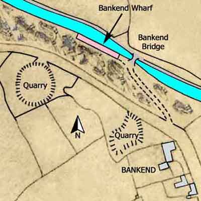
Bankend Quarries
Upper Peak Forest Canal
Grid Ref: SK 000 844
Tithe Map: 1851, Ref: EDT 137/2
Courtesy: Cheshire Archives & Local Studies
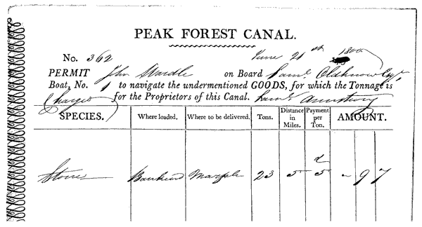
Permit No 362
The permit below was issued on the 21 Jun 1800.
It permitted John Wardle on board Samuel Oldknow Esquire's Boat No. 1 to carry 23 tons of stone from Bankend Wharf to Marple, a distance of 5 miles (actually 4 miles 14 chains rounded up to 5 miles).
It was signed by Samuel Armstrong, the Wharfinger at Bankend Wharf.
Bankend Coal Pits
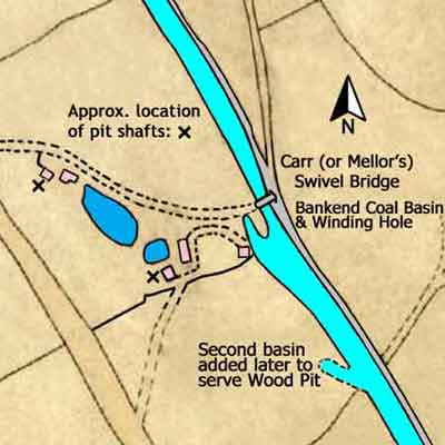
Three coal pits have been identified in the vicinity of Bankend Quarries, one of which was close to the offside of the canal and this has been added to the Tithe Map of 1851 shown below.
Of the other two, one was located between the two quarries off the map to the west and the other was a short distance to the south west of this.
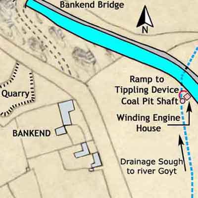
Bankend Coal Pits & Quarries
Upper Peak Forest Canal
Tithe Map: 1851
Courtesy: Cheshire Archives & Local Studies
The winding engine house for the pit by the canal was positioned between the shaft and the canal. It was a tower-like, stone-built structure, about 30 feet tall, that was rectangular in plan with a gable roof. When full coal tubs reached the pit bank they were at a higher level than the canal. From the pit bank, the rails for the coal tubs curved round the engine house on a ramp down to the canal where there was a tippling device used to load boats with coal. A tapered stone retaining wall was built by the canal to support the ramp. Over the years, mining subsidence caused the engine house to lean towards the shaft.
The diagram below shows the conjectural arrangement of the winding engine house and headgear. The winding drum was set near the top of the building and it was driven by a vertical steam winder positioned beneath it. The headgear was of timber construction and it was supported by the gable end of the engine house. A possible variation to the winding arrangement was that another rope was wound onto the winding drum in the opposite direction, passing over an additional pulley at the top of the headgear and attached to a second mine cage. In this instance, when the winding drum was set in motion, one cage ascended the shaft while the other descended.
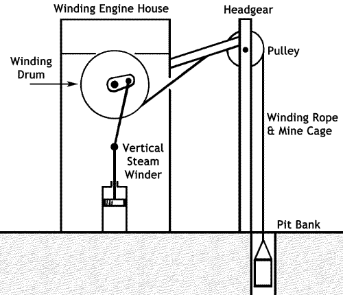
The location of the boiler house is uncertain but most likely it was on the side of the engine house away from the ramp leading down to the canal. In layout, it could have been either detached from it or a lean-to type building at the side of it.
Three mines (seams) of coal were worked, namely Red Ash Mine, White Ash Mine and Yard Mine respectively. To give a perception of the depths of these mines, at Railway Pit, Whaley Bridge, they were 49, 69 and 117-yards deep, respectively.
The shaft was probably sunk in the early 19th century, with a possibility that that it could date from shortly after 1796 when the Upper Peak Forest Canal opened. However, the winding engine house is considered to be of later construction, perhaps due to modernisation, and it most likely dates from between 1820 and 1840. There are no records of early ownership but it is known that the Boothman family of Furness Vale, Thomas and John William, were coal masters, lime burners and carriers by canal. Consequently, it is possible that the Boothman family operated this pit for a while. It appears that the pit might have become rundown or even disused at some point and between 1868 and 1873 Levi and Elijah Hall went into the workings to remove the pillars of coal left by earlier owners. The 1851 Tithe Map records that the plot of land where the shaft was sunk was known as the Dower & Marled Field, owned by John William Jodrell and occupied by John and William Ollerenshaw.
These were situated on the offside of the canal between Newtown and Furness Vale. The later Wood Pit was the most southerly of this group of pits.
Bankend Coal Basin & Coal Pits
Upper Peak Forest Canal
Grid Ref: SK 004 840
Tithe Map: 1851, Ref: EDT 137/2
Courtesy: Cheshire Archives & Local Studies
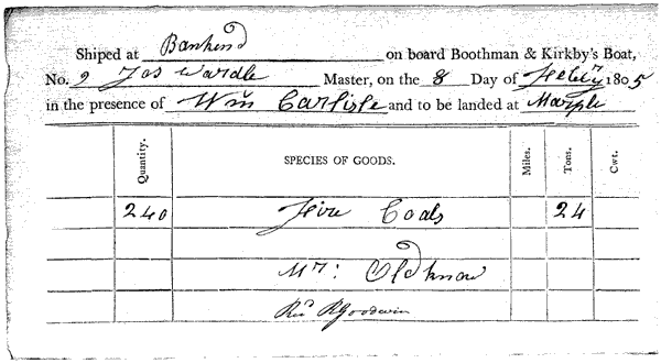
Shipping Note
The note below was issued on the 8 Feb 1805.
It recorded that James Wardle on board Boothman & Kirkby's Boat No. 9 carried 24 tons of fire coals from Bankend on the Upper Peak Forest Canal to Marple.
The journey started at Bankend in the presence of William Carlisle and the coals were received at Marple Lime Works by R Goodwin who was Samuel Oldknow's Clerk.
The distance between the pit and Marple is 4 miles 44 chains.