
Plain Pit Basin and Plain Pit were situated on the offside of the canal a short distance to the south of the Newton Wood Private Branch and Newton Wood Stop Place. The name was taken from nearby field names in the township of Newton. The earliest known record of the pit is in Sep 1835 when the Dunkirk Coal Company gave notice that it was to commence working Plain Pit. Whether the company was establishing a new pit or taking over an existing pit is unclear. It was also their intention to sink a shaft on the towpath side of the canal. A bridge was to be built across the canal and one steam engine was to wind both shafts. This meant that the winding rope from the second shaft would pass over the canal. A sub-committee of the Peak Forest Canal Co agreed to this on the condition that there was 9-feet clearance over the canal and towpath. This bridge is shown on the Tithe Map but there is no evidence of a second shaft. This pit worked the Roger and Great Mines.
For details of Dunkirk Coal Company click here » Dunkirk Coal Co
In Dec 1840, the coal company gave notice of their intention to take coal from under the canal. The canal company would not have readily agreed to this because of the high risk of subsidence once the coal had been removed. Although the outcome of this is unknown, the usual solution was for the canal company to pay for the coal left in the ground.
Referring to the Tithe Map, a bridge is shown across the narrow part of the basin and it is possible that a waggon tippling device was mounted on this to enable boats to be loaded with coal. The schedule accompanying the map does not give any details of the owner or occupier of the plot of land where the pit was located.
The Ordnance Survey map of c.1875 shows the pithead buildings to be still extant but the basin has been filled in and the bridge across the canal removed. This implies that Plain Pit was closed by this time. Nowadays, the only trace of the former existence of Plain Pit is a street of the same name off the west side of Dukinfield Rd.
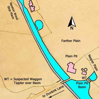
Plain Pit & Basin
Lower Peak Forest Canal
Grid Ref: SJ 938 963
Tithe Map: 1847, Ref: EDT 292/2
Courtesy: Cheshire Archives & Local Studies