Edge Hill
This township lies just east of Liverpool and it is situated on top of an escarpment that rises from the river Mersey.
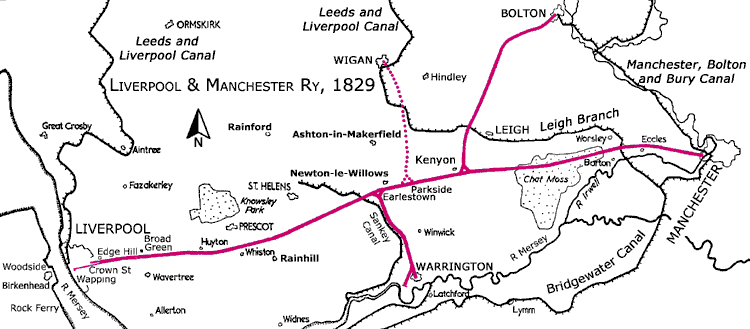
To access Crown Street Station and Wapping Goods Station (for King’s Dock) the deep Cavendish Cutting was cut through solid rock. At the bottom of this cutting two tunnels were originally bored.
One was the short tunnel to Crown Street Station and the second was the 1¼-mile-long Wapping Tunnel to Wapping Goods Station (Park Lane), for King’s Dock that closed in 1972.
The latter tunnel runs below Crown Street Station. By 1846 a third tunnel (with double track) was bored to Crown Street to provide an additional goods line.
Ultimately, Edge Hill became a busy railway junction with sidings and a goods terminal with three tunnels at the end of Cavendish Cutting.
In 1836 the new Lime Street Station was accessed via the 1⅛-mile-long Lime Street Tunnel. However, in the 1880s part of this was converted into a cutting.
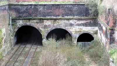
The abandoned Cavendish Cutting viewed from Chatsworth Drive Bridge, Edge Hill.
From right to left the three tunnels at the bottom of the cutting are: Crown Street Tunnel (1830) to Crown Street Station;
Wapping Tunnel (1830) to Wapping Goods Station; and a short goods tunnel (1846) to Crown Street. The latter was driven through an original storage recess.
Early Railway Branches
Originally, the railway between Kenyon and Bolton was in two sections. The Act for the 7¾-mile-long Bolton and Leigh Railway received the Royal Assent on the 31 March 1825 and
the Act for the 2½-mile-long Kenyon and Leigh Junction Railway received the Royal Assent on the 14 May 1829.
The Act for the 4½-mile-long Warrington and Newton Railway received the Royal Assent on the 4 May 1829.
The Act for the 7-mile-long Wigan Branch Railway between Wigan and Parkside/Newton received the Royal Assent on the 29 May 1830.