
Classification
Four batteries of lime kilns were built in the environs of Bugsworth Basin at the terminus of the Peak Forest Canal, namely:
Hence, a total of 19 kilns were built around the basin but they were not all built at the same time nor were they all operational at the same time.
Map 1 shows the location of the four batteries of kilns at Bugsworth Basin.
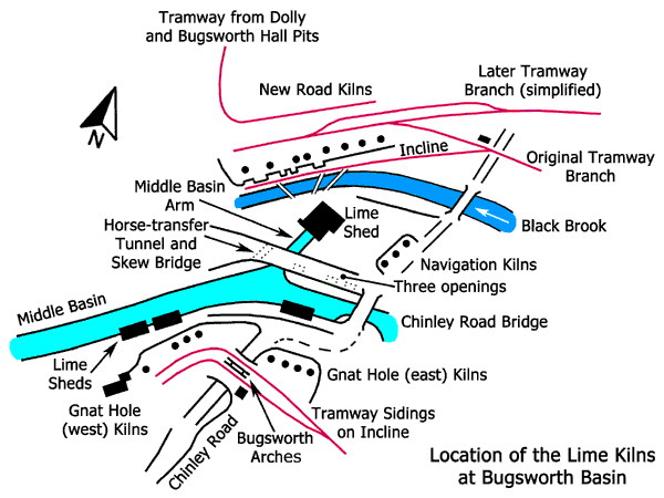
Map 1.
This page is concerned with the Navigation and Gnat Hole Kilns only.
These kilns were located in the obtuse angle formed by the Middle Basin and Chinley Rd (locally known as Brookside). The site adjoins the western end of the Navigation Inn and for identification purposes they are referred to as the Navigation Kilns. No remains are visible today and an extensive archaeological survey would be required to determine the extent of any remains, if any, below ground. In fact, very little is known about these kilns either from documentary or archaeological sources. Two of the kilns predated the construction of the canal and the third was added after the canal opened.
The date of construction of the earliest kilns is unknown, possibly it was sometime in the 18th century, and who operated them at this time is, likewise, unknown. Limestone to be burnt in these kilns would have been brought from the nearest source of limestone in the High Peak and this would have been transported either by packhorse or horse and cart with the former being the more likely. Coal was readily available nearby, either from natural outcrops in the valley side (drift mines) or from shallow bell pits.
According to the Minutes of the Peak Forest Canal Company, Messrs Wright and Brown built a kiln at Bugsworth in 1800 and it is possible that this was the third of the three Navigation Kilns, although there is no evidence to support this. If this conjecture is correct then it is likely to be the northernmost of the three kilns. In 1802 a Mr Wright (of Wright and Brown) occupied the site and in 1811 there is a reference to a Mr Highams on the site. In the same year a lease was passed to Messrs William Hassall and Joseph Satterfield for one year and it is possible that this was for the Navigation Kilns.
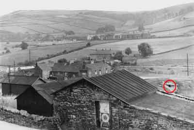
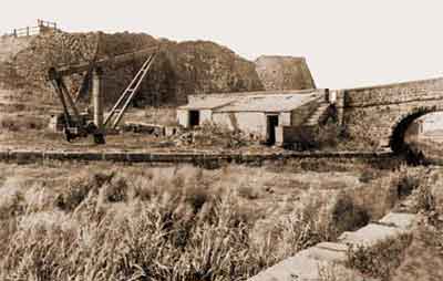
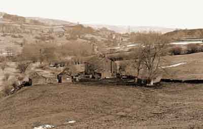
View looking southwards from New Rd, 1950s.
The Navigation Inn is centre left and the red circle on the right highlights what is likely to be the remains of one of the Navigation Kilns. If this supposition is correct then it is possibly the northernmost kiln believed to have been built by Messrs Wright and Brown in 1800.
The opening in the stone wall appears to be an original feature and it may be the remains of the draw hole used to remove burnt lime from the base of the kiln. The stone footings are covered with a roof of corrugated iron
held in place by stones laid out in a circular pattern conforming to the circular section of the kiln. An eyewitness confirmed that the footings of this feature were circular.
Credit: K Holford/M Lomas
Map 2 is based on a map of 1815 and it shows how Bugsworth Basin appeared at this time. It shows two of the Navigation Kilns on the other side of Chinley Rd to the Navigation Inn. As explained above, it is likely that the third kiln was extant by 1815, the surveyors merely having omitted it from their map. This map also shows three tramway sidings that were used to transport limestone to the Navigation, Gnat Hole and New Road Kilns from the quarries at Dove Holes. The map of 1815 was not produced for the specific reason of surveying Bugsworth Basin, as its purpose was quite different.
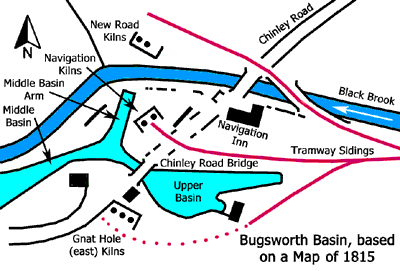
Map 2.
Continuous draw kilns of the type used at Bugsworth required high ground at the back to facilitate charging with limestone and coal, and low ground at the front for the removal of burnt lime and lime ash. The vertical distance between the back and front of the Navigation Kilns was inadequate for efficient combustion and this factor probably had some bearing on their relatively short life after the canal opened in 1796.
The back of these kilns faced Chinley Road to enable them to be charged with limestone and coal and the front was at wharf level for the removal of burnt lime and lime ash. Limestone was brought down the Peak Forest Tramway after it was open and for a short period after 1796 the stone would have come from the quarry at Loads Knowl before coming from quarries in Dove Holes Dale. Coal would have been carted in from nearby drift mines and pits.
Boats waiting to be loaded with burnt lime had a choice of two moorings. One was on the Middle Basin Arm (Mr Satterfield's Branch) after it was open and the other was on the Middle Basin North Wharf adjoining Chinley Road (or Silk Hill) Bridge. It seems that a lime shed was not provided to keep the burnt lime dry while boats were being loaded. Lime ash would be removed by barrow and dumped anywhere along the banks of the Black Brook, as is still in evidence to the present day.
Map 3 is based on a tithe map of 1846 and it shows how Bugsworth Basin appeared at this time. This map shows all three kilns as well as the tramway sidings used to bring in the limestone. There is now a skew bridge over the Middle Basin Arm that provided tramway access to the Lower Basin and the Central Peninsular, the latter being known as 'The Island' in its working days. This skew bridge also improved access to Canal House and Office adjacent to the Entrance Basin. The map of 1846 was not produced for the specific reason of surveying Bugsworth Basin, as its purpose was quite different.
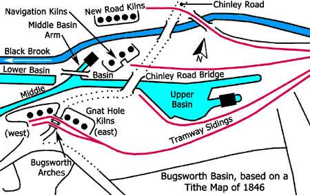
Map 3.
By 1846, a lime shed had been built over the head of the Middle Basin Arm. There is archaeological evidence to show that two lime sheds were built on this site. The earliest one spanned only half the width of the arm on its western side and this was afterwards demolished and replaced by the second, which spanned the full width of the arm. This allowed two boats to be loaded undercover and this reflected an increase in the lime trade at Bugsworth.
The lane leading from Chinley Rd to the bridge over the Middle Basin Arm was along an embankment contained within battered-stone revetments and later this was widened and heightened. At first, it was 15¼ feet wide at wharf level and after allowing for, say, a 10º angle of batter and an embankment height of around 12¼ feet, the width at lane level was about 11 feet.
This revetment was pierced by three asymmetrically spaced openings. The two openings adjoining Chinley Road Bridge had semi-circular arches, while the one by the bridge over the Middle Basin Arm was flat arched, being capped by a large stone lintel. The two openings by Chinley Road Bridge permitted a boat moored on the Middle Basin North Wharf to be loaded with lime from the Navigation Kilns. The purpose of the opening by the bridge over the Middle Basin Arm is unclear, unless it was simply to provide additional pedestrian access between the kiln yard and the Middle Basin North Wharf.
An early development affected the revetment on the south side. An inspection of the wharf openings and the horse-transfer tunnel beyond the skew bridge shows the joint lines between the original revetment and the added width. A second lintel capped the extension to the opening by the bridge, while the two openings by Chinley Road Bridge retained their semi-circular profiles. At this stage access from the kiln yard to the wharf was still possible.
The next development involved widening and increasing the height of the lane. The present skew bridge over the Middle Basin Arm was built and it has different architecture and stone to the flanking revetments. It has no joint lines, which suggests that an earlier bridge was demolished to make way for it. Possibly, this was a temporary wooden trestle bridge. Simultaneously, the north side of Chinley Road Bridge was raised to bring it up to the new level. This work resulted in the lane width being increased to 29 feet, which was sufficient for one tramway track and access for pedestrians and carts.
The reconstruction of the revetment on the north side resulted in the three openings to the kiln yard being covered over and at the same time they were walled-up inside. These alterations meant that access to the Middle Basin North Wharf from the kiln yard was no longer possible, although it was still be possible to load boats moored in the Middle Basin Arm. There is slight evidence that the Navigation Kilns were disused by 1841.
An examination of the revetment on the south side, by the wharf, reveals a vertical joint, which suggests that it was not all built at the same time and that two contractors might have been involved. The quality of the stonework to the right (east) of the joint is superior to that on the left (west).
Combined with this development was the construction of a pier for a mobile waggon tippler on the Middle Basin North Wharf. This work changed its function from lime wharf to limestone pen. An examination of the wharf shows nine large flat stones embedded in the surface at regular intervals. These were the plinths that supported the pier stanchions and each one has a rectangular indentation where the stanchions once stood.
On the northern side of the lane, bordering the site of the Navigation Kilns, there is a low stone revetment topped with copingstones. These carry traces of five wrought-iron studs and perhaps these once secured baulks of timber to the stones. These scant remains suggest that this area might once have been a staithe (raised platform) where coal, brought in by cart, was discharged for firing the Navigation Kilns.
These kilns were located on the south side of the Middle Basin in the hamlet of Gnat Hole and Chinley Rd divided them into two batteries of four kilns each. Two tramway bridges, side-by-side, over Chinley Rd (Bugsworth Arches) connected the two batteries together. For the convenience of identification, these are known as the Gnat Hole (east) Kilns and Gnat Hole (west) Kilns, respectively.
 |
 |
Gnat Hole (east) Kilns viewed from across the Upper Basin, 1930s. Chinley Road Bridge is on the right and the two small buildings to the left of the bridge are workmen's bothies. |
Gnat Hole (west) Kilns viewed from across the Middle Basin, 1930s. One of the kiln pots is visible to the left and the building in the foreground is a workmen's bothy. |
 |
 |
Bugsworth Arches looking down Chinley Rd towards Bugsworth Basin, early 20th century. These arches over the road consisted of two tramway bridges, side-by-side, used to supply the west battery of kilns (to the left) with limestone. They were demolished in Sep 1911. |
The Gnat Hole lime kilns, 1930s.
The east kilns are to the left of Chinley Rd and the west kilns are to the right. By this time Bugsworth Arches that connected the kilns had been demolished. |
 |
Line of the tramway branch used to supply limestone to the Gnat Hole lime kilns, Apr 1983. The branch passed in front of the Rose and Crown Inn. |
Owing to a lack of records, the history and chronology of these kilns is not wholly understood and as a result their interpretation is somewhat problematical. By 1871 the name Bugsworth Lime Works was being applied to the Gnat Hole Kilns but whether this applied to both batteries of kilns or just one is unknown. The same company did not necessarily operate both batteries at any given time.
The Gnat Hole (east) Kilns survived, more-or-less intact until the 1980s when they were completely destroyed to make way for the bypass. The remains of the Gnat Hole (west) kilns are still extant but, following their partial collapse towards the end of the 19th century, they were never repaired. Work on demolishing Bugsworth Arches over Chinley Rd commenced in Sep 1911 and by the 14 Oct 1911 they had been removed. It seems that the landowner, Mr Morten, had readily given his consent for the arches to be demolished, but Buxton Lime Firms, who actually owned the arches, delayed giving their consent.
At the back of the Middle Basin South Wharf, by Chinley Road Bridge, there are three asymmetrically spaced access tunnels to the east kilns. Perhaps the two inner kilns in the battery shared a common access tunnel while the two outer kilns had individual access tunnels. An inspection of these tunnels shows that Chinley Rd was either widened or its alignment was altered while the kilns were still being worked, which resulted in the tunnels being extended in length. The joint lines between the two different sections can still be seen. Nowadays, the headroom in these tunnels is very low but in their working days it would have been somewhat greater, although still limited by the lack of height between the wharf and Chinley Rd. The middle tunnel is of arched construction beyond the joint line while the other two have box sections.
As explained above, the west kilns partially collapsed towards the end of the 19th century so the location and number of access tunnels (or archways) is unknown. In the absence of any archaeological evidence, it is surmised that the three kilns nearest to Chinley Rd shared a common tunnel while the fourth had an individual tunnel. This is because the fourth kiln was built some distance away from the other three.
Three lime sheds were built on the Middle Basin South Wharf to enable boats to be loaded undercover. The shed next to Chinley Road Bridge served the east kilns and it had a ridged roof. One sidewall of this shed sprang from the wharf while the other sprang from the bed of the canal. The other two sheds were a little distance away and they were of similar construction except that their ridged roofs were self-supporting on the canal side.
Gangs of waggons loaded with limestone were hauled up an incline to the kiln heads. The tramway siding ran between the Rose and Crown Inn and a blacksmith's shop. Coal was carted in from local pits and it was also brought in by boat from the Whaley Bridge and New Mills areas. Coal could also have come from Mosley Hall Pit situated on the hillside south of the Bugsworth Basin. There was an inclined plane between the pit and a coal staithe in Gnat Hole. However, it is known that this pit produced domestic quality coal, rather than the low grade and cheaper coal favoured for use in kilns. As a result, this coal may not have been used to fire the kilns but if it were used then it would have required carting the short distance between the staithe and the kiln heads.
The construction of the first of the kilns at Gnat Hole was probably contemporary with the opening of the Peak Forest Tramway and Upper Peak Forest Canal in 1796. These were the east kilns and they were three in number by 1815 (see Map 2). Ralph Morten probably built them and he may have worked them for a number of years as well. Ralph Morten was the landowner and it was still in the ownership of his descendants in 1911.
At an unknown date after 1815, a Mr Bridge might have built the first three kilns in the west battery and these were certainly in existence by 1846 (Map 2). By 1837, Thomas Boothman had leased the east kilns from the Morten family, and between the 29 Sep 1837 and June 1839 he had leased the west kilns from the Peak Forest Canal Company at a rent of £3 per annum. In 1844 Thomas Boothman, John William Boothman and Gisbourne Babington were the lessees and occupiers of these kilns.
The construction of the fourth of the west kilns is of interest. It was built after 1846 and it was sited some distance away from the other three. Possibly it was planned to insert another kiln in the intervening space should the demand for lime increase.
There is a long gap in the documentation between 1844 and the 11 Oct 1866 when there is evidence to show that the firm of Levi Maiden & Company was in business at the Canal Lime Wharf, Lancashire Hill, Stockport, on the Stockport Branch of the Ashton Canal. By this time the Gnat Hole kilns were known as Bugsworth Lime Works but whether this referred to both batteries or one is unknown. It is known that Sampson Maiden was active at Bugsworth and he was a partner in the firm of Levi Maiden & Company. Sampson and Levi were brothers. This company was still working the kilns in 1877 but for how long afterwards is uncertain. By the 3 May 1890 these kilns were leased to a Joseph Heathcott of Chapel-en-le-Frith and on 1 Aug 1891 they became part of Buxton Lime Firms Company Ltd (BLF). This merger was significant in the development of the chemical industry in the United Kingdom. In 1916, Brunner Mond of Northwich, Cheshire, acquired a controlling interest in BLF and Brunner Mond became part of Imperial Chemical Industries (ICI) on its formation in 1927. It is considered unlikely that there was another operator between Levi Maiden & Company and Joseph Heathcott who was possibly associated with Heathcott & Sons who, at the beginning of the 1890s, had a number of retail lime outlets in the North West, including Ashton, Stockport, Manchester and Liverpool.
During the 1890s, disaster struck the Gnat Hole Kilns when the facing wall of the west kilns collapsed and was never repaired. This incident left the four east kilns intact but for how much longer they were worked is unknown. Bugsworth resident, Mrs Martha Barnes, recorded in her memoirs that towards the end or their working lives only two of the four Gnat Hole (east) Kilns was were burning full time. Lime burning at Bugsworth Basin started to decline in the 1880s and the evidence for this can be seen in the decreasing value of kiln rents. It is possible that by the early 20th century that all the east kilns were disused but still in working order.
At the back of the east kilns there was a small single-storey building. It was stone built with a ridged roof and gable ends and a chimneystack at one end. Its purpose is unknown unless it was a bothy for workmen. Because of its proximity to Bugsworth Arches, it is likely that this building was demolished in 1911 at the same time as the demolition of the arches.
In the 1980s, during construction of the bypass, the east kilns, tramway incline to the head of the kilns, and the abutments of Bugsworth Arches were completely destroyed. The Rose and Crown Inn, the blacksmith's shop and the remains of a stable block were also destroyed.
 |
 |
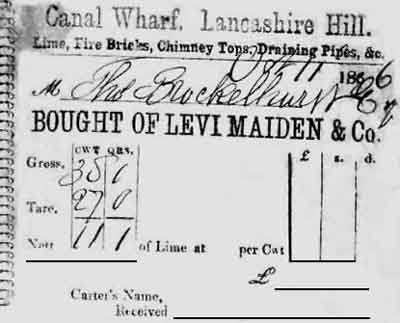
Delivery Ticket issued at the Canal Lime Wharf, Lancashire Hill, Stockport, (Levi Maiden & Company). This delivery ticket, dated 11 Oct 1866, is for 11 cwt 1 quarter of lime delivered to Thomas Brocklehurst Esquire. Weight of cart and contents (Gross weight) - weight of cart (Tare weight) That is, 38 cwt 1 quarter - 27 cwt 0 quarter |
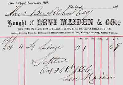
Invoice issued at the Canal Lime Wharf, Lancashire Hill, Stockport, (Levi Maiden & Company). This is dated 26 Oct 1866 and it is in settlement of the sale of 11 cwt 1 quarter of lime delivered to Thomas Brocklehurst Esquire at a cost of 6s 9d. It was signed by Levi Maiden. |
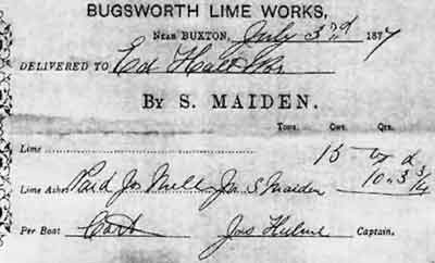 |
Delivery Ticket issued at Bugsworth Lime Works (Levi Maiden & Company). This delivery ticket, dated 3 Jul 1877, is for the sale of 15 cwt of lime from Bugsworth Lime Works at a cost of 10s 3¾d. The lime was sold by Sampson Maiden and it was delivered by cart, the carter being James Hulme. |
Acknowledgement
D Hudson for the delivery ticket and invoice issued by Levi Maiden & Company at Stockport.
