
Records of coalmining in Denton and Haughton can be traced to the early 1700s and there are indications that it went much further back than this. One early record can be found in the Parish Registers of Denton Chapel (St Lawrence's Church) for 1743.
Buried. John Bretland of Whernith, who was killed in ye Colepit in Haughton.
There were numerous shallow pits throughout the townships of Denton and Haughton but the names, and even the whereabouts, of some of these are now lost. The sites of some of these can be found on old Ordnance Survey maps, where they are marked as 'Old Coal Shaft' or 'Old Air Shaft' but without names. The following is a list of some known coal mines (aka pits) together with available details.
Old Burton Nook Pit, DentonThere is some evidence that this was an 18th century pit situated in the hamlet of Burton Nook on the north side of Stockport Rd.
Denton Colliery (Ellis Pit or new Burton Nook Pit)The shaft was sunk in 1841 on the north side of Stockport Rd and about 240 yards to the east of the hamlet of Burton Nook.
It was sunk by John Fletcher, the uncle of Jacob Fletcher Fletcher. It was used as the upcast shaft for the extraction of stale air and as the coal elevator.
Top Pit, Denton This pit was located on the south side of Stockport Rd and about 180 yards distant from Denton Colliery.
This was the downcast shaft used as an elevator by miners to access Denton Colliery and for the supply of fresh air. Between Top Pit and Stockport Rd there was another shaft known as Fox Pit.
Great Wood Pit, DentonThis pit was the second most important coal mine in the vicinity after Denton Colliery.
It was situated to the south of Stockport Rd, between Cemetery Rd and the top of Hardy Wood, about 525 yards distant from the upcast shaft of Denton Colliery.
Latterly it was used as a pumping station to drain Denton Colliery.
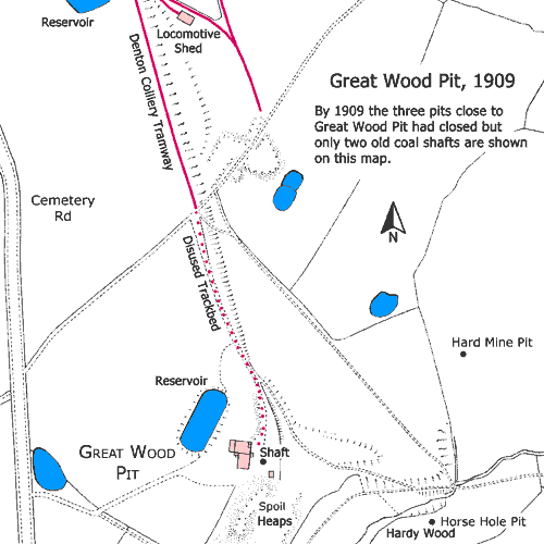
Hard Mine Pit, DentonThis pit was a short distance to the north of Hardy Wood, close to Great Wood Pit. As its name suggests, it was the Hard Mine (seam) that was being worked.
Horse Hole Pit, Denton This pit was at the top of Hardy Wood, close to Great Wood Pit, and it was recorded that its shaft was being sunk in May 1846.
It obtained its name from the entrance to the shaft, known as a 'horse hole, where horses were netted and lowered down the shaft to work underground.
The Hard Mine (seam) was also worked in this pit.
Unidentified Coal Pit, DentonThere is slight evidence that there might have been a third pit in close proximity to Great Wood Pit but its location and identity are unknown.
Hulme's Pit, DentonThis pit was situated by Hulme's Ln at the foot of Beat Bank alongside the river Tame. It dates from c.1730 but at an unknown date it was taken over by the
Fletcher family/Denton Colliery Co Ltd who eventually used it as both a coal mine and a pumping station to drain Denton Colliery.
It is likely that there were ancient and unrecorded drift mines in this vicinity that had been driven into the valley side at locations where natural coal outcrops occurred.
Unidentified Drift Mine, DentonThis was situated by Hulme's Ln between Hulme's Pit and Stockport Rd.
Donkey Pit, DentonIn Hulme's Wood close to Hulme's Pit and could be synonymous with it. It is believed that it got its name from a horse gin used for winding purposes.
Unidentified Coal Pits, DentonThese adjoined Hulme's Pit and it is likely that they were earlier bell pits that were superceded by Hulme's Pit.
Unidentified Old Coal Pit, Denton Further along Hulme's Ln, by the river Tame, there was an 'Old Coal Pit' roughly opposite Arden Mill.
Arden Colliery, Lower HaughtonSituated near Arden Bridge over the river Tame.
Bayley Pool Pit, DentonThis pit was situated in Reddish Vale between the southern end of Horse Close Wood and a loop in the river Tame known as Bayley Pool.
Dark Lane Pit, Haughton GreenSituated on the east side of Dark Ln, now called Mill Ln.
Hardfield Pit, Haughton GreenSituated on the east side of Dark Ln, now called Mill Ln.
Broomstair Colliery (aka Broomstair Pit), HaughtonSituated on the south side of Hyde Rd, close to Broomstair Bridge over the river Tame.
An early reference to this pit is to be found in Wheeler's Manchester Chronicle for the 14 Jan 1809:
Another reference is for an unnamed coal pit shown at the location of Broomstair Colliery on the 1848 Ordnance Survey map.
By 1859 until c.1878 Broomstair Colliery was operated by Messrs Silas Leigh and John Bradbury who also operated Clayton Colliery in Manchester. They were followed by the Hyde and Haughton Coal Company from c.1878 until c.1890. Broomstair Colliery and the nearby Hyde Colliery (aka Hyde Lane Pit) were both operated by the Hyde and Haughton Coal Company (aka the Hyde and Broomstair Coal Company) and the proprietors were the brothers Joseph Watson Sidebotham MP (1857-1925) and James Nasmyth Sidebotham (1864-1904), of Bowdon, Cheshire, who were local landowners. In c.1890 Broomstair Colliery was sold to the Dukinfield (New) Coal and Cannel Company Ltd who owned it until its closure and abandonment in 1898.
Following the flooding, some Broomstair Colliery employees found work at the nearby Hyde Colliery and one of these, Thomas Shaw, was killed in the Hyde Colliery Explosion that occurred seventeen days later on the 18 Jan 1889.
In 1896 there were 298 underground workers and 65 surface workers at Broomstair Colliery. The Manager was Richard Clay and the Under Manager was James Gee. The Great and Roger Mines were being worked.
For details of Broomstair House, office of Broomstair Colliery, click here » Broomstair House
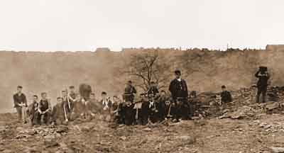
Broomstair Colliery, Haughton, 1893.
During the autumn of 1893, coal miners' strikes occurred in the Lancashire, Yorkshire and South Wales coalfields that resulted in coal shortages and this photo shows townsfolk scavenging for coal on the spoil heaps of Broomstair Colliery.
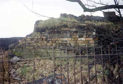
Broomstair Colliery, with the remains of a coal staithe at the side of Hyde Rd, Apr 1990.
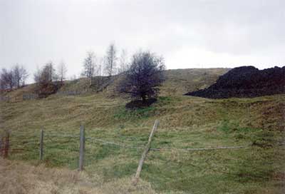
Broomstair Colliery, with spoil heaps at the side of Hyde Rd, Apr 1990.
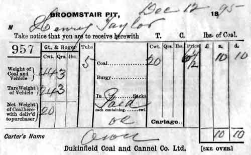
Ticket No. 957 issued on the 12 Dec 1895 by the Dukinfield Coal and Cannel Co Ltd.
It permitted a carter to deliver 20cwt of coal to Henry Taylor.
The coal was from either the Great or Roger Mines at Broomstair Pit, Haughton, Denton.
This was the highest grade of coal from the colliery.
Gross weight of 5 tubs of coal = 44cwt  3qrs
         Tare weight of 5 tubs = 24cwt  3qrs
              ∴ Weight of coal = 20cwt  0qrs

∴ 20cwt of coal at 6½d per cwt = 10s  10d
  Credit: C Hartley
Jet Amber Pit, HaughtonSituated in Jet Amber Fields in the vicinity of Farmers Fold on the north side of Hyde Rd. This pit worked the Old and New Jet Amber Mines.
Unidentified Pit, HaughtonSituated in the vicinity of Quebec St on the east side of Ashton Rd, between Greswell St and Tame St.
Unidentified Pit, HaughtonSituated in the vicinity of Pit St on the east side of Stockport Rd. The Jolly Hatters stands on the corner of Pit St and Stockport Rd.
Albert Pit, HaughtonOff Tib St, behind the Masons Arms Public House at Three Lane Ends. It was owned by the Denton Colliery Co Ltd. It is understood that this pit closed in 1886.
Parsonage Pit, HaughtonSituated between Tib St and Vaudrey Ln, it was about 250 feet from the north-west corner of the Old St Lawrence's Rectory, at the bottom of Vaudrey Ln.
It was owned by the Denton Colliery Co Ltd. It is understood that this pit closed in 1886.
Sycamore Pit, HaughtonThis pit was said to have stood on the corner of Tib St and its name might be synonymous with Roger Mine Pit.
It was in close proximity to Albert Pit and Parsonage Pit. There was a Sycamore Inn off Tib St that stood at the back of St Lawrence’s cricket ground on
land between Tib St and Whittles Farm. The cricket ground is at Sycamore Park, Clayton St.
Victoria Colliery, Haughton GreenThis colliery was owned by Thomas Shaw & Sons but in 1873 it was purchased by the Denton Colliery Co Ltd.
It is likely that the local name for this colliery was Nibble and Clink Pit, sometimes known as Nibble or Nibland Pit.
It was located on the north side of Haughton Green Rd near the Bay Horse Public House, opposite the entrance to Gibraltar Ln.
It is understood that the pub was named after a favourite pit pony.
A Newcomen type atmospheric steam engine may have been installed here and the pit got its name from the noise made by the flat winding rope used.
Unidentified Pit, Haughton GreenBehind the Wesleyan Chapel (Haughton Green Methodist Church) on Two Trees Ln.
King Pit, Haughton GreenAdjoining Betty's Park (later Tommy Dodd).
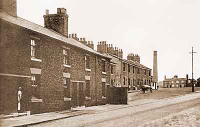
Haughton Green Rd, early 20th century.
King Pit Cottages, built in 1793, are on the left and between them and the next row of cottages was the entrance to King Pit and King Pit Farm. The single-story white building at the far end is the original Cricketer's Arms.
The tall chimney in the background pinpoints the position of Victoria Colliery (aka Nibble and Clink Pit) near the Bay Horse public house. The chimney was demolished in 1923.
Clinker Pit, Haughton GreenSituated on Worth's Ln opposite St Mary's Church. The last record of mining activity at this pit was in 1882.
No doubt this pit received its name from the type of ash produced when its coal was burnt. Clinker consists of a hard mass of ash and partially fused coal.
Unidentified Pit, Haughton GreenSituated about 275 yards east south east of Haughton Terrace on Meadow Ln. This pit closed sometime in the second half of the 19th century and
was not marked as an 'Old Shaft' on Ordnance Survey maps at the turn of the 20th century. Access to it from Haughton Green Rd was by way of a lane where Church Avenue and Rivermead Rd now stand.
Haughton Colliery, Haughton GreenSituated at Glass House Fold on the south side of Mill Ln in the angle formed by the lane and the river Tame. This colliery was owned by Thomas Shaw & Sons.
The proprietors were Thomas Shaw Sr and sons, William Shaw, Thomas Shaw Jr and Samuel Shaw.
In 1861 Thomas Shaw Sr was resident at Lowe’s Fold, Two Trees Ln, Haughton, occupied as a coal proprietor. He was born at Saddleworth, Yorkshire, in 1796/97.
Dans Wood Drift Mine, Haughton GreenSituated at Glass House Fold in the valley side.
Wilton Pit, DentonExistence and location uncertain.
Angel Pit, HaughtonHearsay evidence only. If it existed, then it was probably located near the Angel Inn on Hyde Rd.
Unidentified Air Shaft, DentonOn the west side of Seymour St, north of Holland St. The shaft was around 167 yards deep and it was near the Pentecostal Church.
The National Coal Board filled and capped this shaft in 1965.
Unidentified Pit, HaughtonOn the south side of Hyde Rd, opposite St Anne's Rd. This pit was close to Broomstair Colliery.
Unidentified Pit, Haughton GreenAbout 330 yards almost due south of Glass House Fold, alongside the river Tame.
Unidentified Air Shaft, HaughtonAbout 235 yards north east of St Anne's Church. This air shaft may have been associated with Broomstair Colliery.
