
In the early 1820s a canal was planned to connect the Cromford Canal at Cromford Wharf with the Whaley Bridge Branch of the Peak Forest Canal at Whaley Bridge, lying on the opposite side of the White Peak to the north west. Nevertheless, a canal such as the one proposed would have been impracticable across such mountainous terrain, so the idea was dropped and a railway was built instead. The Enabling Act that empowered the Cromford and High Peak Railway Company to make and maintain a railway between Cromford and Whaley Bridge was passed on the 2 May 1825, 6 George IV Cap 30. The first General Meeting of the newly incorporated company was held on the 26 May 1825.
An Act for making and maintaining a Railway or Tram Road from the Cromford Canal, at or near to Cromford, in the Parish of Wirksworth, in the County of Derby, to the Peak Forest Canal, at or near to Whaley (otherwise Yeardsley-cum-Whaley), in the County Palatine of Chester.
Josias Jessop (1781-1826), William Jessop's son, was appointed as the consulting engineer. The estimated cost of building the undertaking was £164,000 but, in the event, this proved to be a major underestimate. Following Jessop's untimely death in 1826, he was replaced by Thomas Woodhouse who became the resident engineer for its construction.
Cromford lies in the parish of Wirksworth in the County of Derby and Whaley Bridge lay in the County Palatine of Chester but today, as a result of boundary changes, it is in the County of Derby.
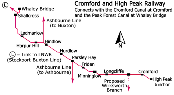
This standard gauge (4 feet 8½ inches) railway was initially built with cast-iron edge rails of the fish-belly type secured to stone sleeper blocks and it was opened in two sections. The first was from Cromford Wharf (later extended to join the Midland Railway at High Peak Junction) to Hurdlow, a distance of 15½ miles, which opened on the 29 May 1830 and the second was from Hurdlow to Whaley Bridge, a distance of 17½ miles, which opened on the 6 Jul 1831. Its summit level was more than 1,200 feet above sea level.
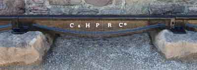
Fish-belly rail, Cromford and High Peak Railway.
Most of all, it is remarkable in that it was a railway built in the manner of a canal with inclines being substituted for flights of locks. In order to reduce earthworks along the summit section to a minimum this was built as a very winding contour railway that resulted in numerous tight bends. In some instances the railway almost seemed to double back on itself. Where earthworks were unavoidable, the result was a number of huge embankments and narrow cuttings. A 19th century writer described it as, 'the sky scraping High Peak Railway with its corkscrew curves that seem to have been laid out by a mad Archimedes endeavouring to square the circle.'
The main purpose of the railway was for the transportation of minerals, such as limestone, lime, coal and iron, as well as general goods.
Details of the inclines are as follows:
It should be noted that, depending upon which company record is referred to, then the gradients do vary slightly from the values given above and over the years some of the gradients were modified, particularly that of the Hopton incline when it was found that locomotives could climb it.
It is known that the Butterley Company built the stationary engine at Middleton Top and in view of this it is probable that this company built all the stationary engines used on this railway. Between 1792 and 1806, this company traded as Benjamin Outram & Company.
The source of power for the Wirksworth Branch incline is rather enigmatic. The 'engine house' consisted of a large stone-built plinth surmounted by a concrete floor, on top of which stood a complex framework of heavy-duty timber. In this respect, it more resembled a horse gin than it did an engine house.
The Cromford and High Peak Railway is celebrated for its many curves and on the summit, between Longcliffe Goods and Friden, there were 21 curves of 110 yards radius or less, three of these being 66 yards, while one, the record holding Gotham Curve, had a radius of only 55 yards, the line turning through 80º.
There were four tunnels on the railway and these were located at Hopton, Newhaven, Hindlow* and Burbage.
When the railway first opened, waggons were hauled by horses along the more level sections and afterwards by steam locomotives. To begin with, it took about two days to traverse its full length.
Steam locomotives were first introduced in 1833 but it is understood that these were complemented by horse haulage for about another 30 years. Following the introduction of steam locomotives, it was discovered in 1877 that they could tenaciously climb the Hopton incline, which had a gradient of 1 in 14.
An official passenger service was operated on the Cromford and High Peak Railway between 1874 and 1877 and during this period there was one train daily throughout the length of the line, in each direction. This service ceased in 1877 following a passenger being involved in a fatal accident.
Nevertheless, this was not the first passenger service on the railway. It seems that German Wheatcroft & Sons operated the first service under contract and this commenced in May 1833. For the convenience of passengers travelling on the railway, this firm also ran a coach service between Whaley Bridge and Manchester. It is not known when these railway and coach services ceased running. Various trade directories show that this firm was also a 'Conveyancer by Water'. German Wheatcroft and his sons managed this firm but German was the first Wharfinger (Manager) at Bugsworth Wharf at the terminus of the Peak Forest Canal when the upper level opened for trade on the 31 Aug 1796. German had disappeared from Bugsworth by 1805 to reappear in 1808 as the person in charge of the self-acting incline on the Peak Forest Tramway at Chapel-en-le-Frith. He was dismissed from the canal company in 1809 and subsequently he established his own successful carrying company know as German Wheatcroft & Sons. German Wheatcroft was Christened at Crich, Derbyshire, on the 9 May 1773, his parents being Abraham Wheatcroft and Ann Turner. He died in the Belper Registration District on the 11 Oct 1841, aged 66 years.
On the 30 Jun 1862 the Cromford and High Peak Railway (Lease) Act was passed and this leased the railway to the London and North Western Railway for 999 years. On the 19 Jul 1887 the London and North Western Railway Act gave powers for the two companies to amalgamate. This allowed the northern section of the Cromford and High Peak Railway to be modernised. On the 4 Aug 1890 the LNWR was given the power to abandon the railway to the north of Ladmanlow with the exception of the section between Shallcross Goods and Whaley Bridge. The sequence of events is as follows.
By the time of the 'Beeching Era', trade from local limestone quarries was decreasing and another section of line closed in 1963, this being the Middleton incline. The section between Middleton and Parsley Hay closed on the 30 Apr 1967 and this included the Sheep Pasture and Hopton inclines, the latter, with its gradient of 1 in 14, being the steepest adhesion stretch of railway line in Britain. The final section, between Friden and Parsley Hay, closed in Sep 1967.
In 1971, the Planning Board of the Peak District National Park, in collaboration with Derbyshire County Council, bought much of the track bed and used it to create the High Peak Trail. This is now a national route of the National Cycle Network as well as being popular with walkers and horse riders. Part of the trail is also designated as a section of the Pennine Bridleway. The engine house of the Middleton incline at Middleton Top was preserved as a Visitor Centre and the beam engines, once used to haul waggons, are occasionally demonstrated with compressed air. Near Cromford, the railway passed below Black Rocks and this is a popular locality for climbing.
An additional attraction for visitors to the area is the Steeple Grange Light Railway, which is a narrow gauge railway that runs along the track bed of a former branch line of the Cromford and High Peak Railway near Wirksworth. This 18-inch gauge railway was built in 1985 on part of the former Killer's Branch to Middleton Quarry from Steeple House Junction on the Cromford and High Peak Railway. This line features a 1 in 27 gradient and there are two operational passenger locomotives as well as two works locomotives and others are under restoration. Two extensions to this line are being studied, one is to the National Stone Centre and the other is an extension up the gradient towards Middleton Quarry.
The later (1899) Asbourne Line between Buxton and Ashbourne left the Cromford and High Peak Railway at Parsley Hay and the southern section now forms part of the National Cycle Network and is known as the Tissington Trail. The heyday of this line was in the 1930s when it was extensively used by ramblers because of its proximity to Dovedale. For a time, there was also a through service between London (Euston) and Buxton via Nuneaton, Uttoxeter and Ashbourne but this was discontinued in the early 1950s.
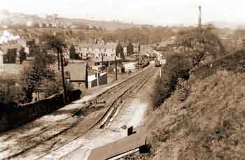
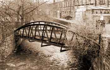
At Whaley Bridge, it is possible to explore the short incline that brought goods down the hillside and across an iron bridge over the river Goyt to the transhipment warehouse and wharf at the terminus of the Whaley Bridge Branch of the Peak Forest Canal. It is also possible to see the site of the horse gin that was used to operate the incline.
From Whaley Bridge, it is a one-mile walk along the towpath of the Peak Forest Canal to visit the Ancient Monument of Bugsworth Basin at the terminus of the main line of the canal. This was the interchange between the Peak Forest Tramway and the Peak Forest Canal and nowadays it is possible to explore part of the tramway by walking along the Tramway Trail.
A recent project by English Heritage was to carry out a heritage audit of both the Cromford and High Peak Railway and the Peak Forest Tramway and this took the form of an archaeological survey of each of them. The purpose of this was to gather together a quantity of related information to help forthcoming management decisions about their appropriate preservation and suitable presentation to the public. An ensuing stage of this project will be to work out an overseeing agenda for each route. It is anticipated that this will be integrated with better visitor information about the proper interpretation of remaining features as an aid to the better understanding of their historic context and importance.
 |
 |
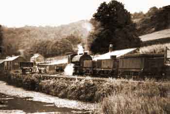
Cromford Wharf on the Cromford Canal with the transhipment warehouses on the left, 1950s. The locomotive is an unidentified Class J94, 0-6-0ST. This class was introduced in 1943 and they were bought from the Ministry of Supply in 1946. |
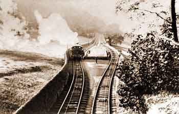
Sheep Pasture incline, 1904. Class 1P LNWR 2-4-0T 'Chopper' locomotive ascending on the winding rope. The locomotive is using power to assist the stationary engine at the top of the plane. The catchpit between the tracks is a safety device to catch runaway waggons in the event of the rope snapping. Note the Pointsman's cabin on the right at the convergence of the tracks. |
 |
 |
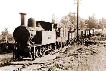
Class 1P LNWR 2-4-0T 'Chopper' locomotive, BR No. 58092 (formerly LMSR No. 26428), below Black Rocks, Jun 1960. This locomotive was built in 1877 for the LNWR and it is seen here hauling a goods train between Sheep Pasture Top and Middleton Bottom. |
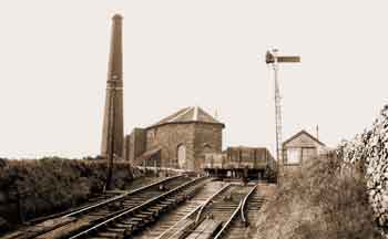
Middleton Top, 1930s. The winding engine house for the Moddleton incline is on the left with the boiler house behind it. Safety catch points can be seen in the foreground and the pointsman's cabin is on the right with a signal beside it. |
 |
 |
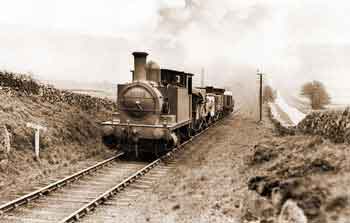
Class 2F 0-6-0T locomotive (LMS Nos 7527 & 25527, BR No. 58860) ascending Hopton incline, May 1934. This is an ex-North London Railway locomotive. |
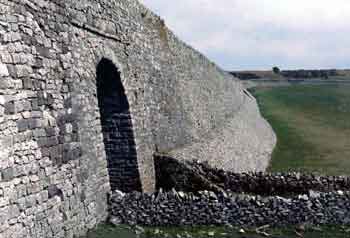
The Minninglow embankment incorporating a farm underpass, 1980s. |
 |
 |
View looking down the Whaley bridge incline, 1950. This incline was operated by a horse gin (horse capstan or whim) and chain. Its mode of operation never changed until its closure on the 9 Apr 1952. |
The wrought-iron railway bridge over the river Goyt at Whaley Bridge, Mar 1979. View looking downstream towards Goyt Mill. This iron bridge only carried a single track. |
The following article appeared in The Derby Mercury on the 3 Feb 1841