Stockport Branch Canal
Locally known as the Lanky Cut, construction of the Stockport Branch Canal of the Ashton Canal was authorised by the second Act of the Ashton Canal Company (33 George III Cap. 21, Royal Assent on 28 Mar 1793).
This authorised the construction of a lock-free branch from between locks 10 and 11 of the Ashton Canal at Clayton to the top of Lancashire Hill in Stockport/Heaton Norris via Openshaw, Gorton/Abbey Hey and Reddish.
The same Act also authorised the construction of a lock-free branch (Beat Bank Branch Canal) from the Stockport Branch at Taylor's Barn, Reddish, via Beat Bank, Denton, for the purpose of serving coal mines around Burton Nook,
Denton. In the event, the Beat Bank Branch was abandoned before work on its construction was completed.
The Stockport Branch opened for trade in Jan 1797 and in due course it became heavily industrialised over most of its length. It was principally used to supply coal to the many factories and mills along its length, as well as coal for domestic use. Furthermore, it carried raw cotton to the mills, general cargo and finished goods. It was also noted for carrying supplies of grain to Albion Corn Mill (W Nelstrop & Company) at Stockport Canal Basin. In the early years of operation, there was also a passenger-carrying service between Manchester and Stockport.
From the start, the canal was very busy but as the 19th century progressed it became subject to competition from the rapid development of rail and road transport that produced a long period of decline. By the 1920s there was very little trade throughout its length although factories and mills took advantage of it for water supplies. By the 1930s trade had virtually ceased and the canal was becoming overgrown, particularly with reeds. This deterioration continued until the 1950s by which time the canal was, to all intents and purposes, unnavigable although it was still physically intact. During the 1950s it was dredged in an attempt to attract some trade back but this work was of no avail. In 1962 the British Transport Commission (precursor of British Waterways) officially abandoned it. Work on filling in the canal commenced in the same year and there is evidence to show that this was being undertaken to the south of Gorton Aqueduct. Nevertheless, work of filling it in became very protracted and it was not completed until c.1975.
Please use the Scrollbar to scroll down the map of the Stockport Branch Canal.
| Distance from Clayton Junction | Miles | Chains |
|---|---|---|
| Clayton Junction between locks 10 and 11 of the Ashton Canal | — | — |
| Ashton Old Road Bridge (Pack Horse Bridge or Openshaw Bridge), Openshaw | 0 | 45 |
| Ogden Lane Bridge (Crab Croft Bridge), Gorton. | 0 | 59 |
| Canal arm into Gorton Canal Depot and Boat Dock with Side Bridge (towpath side). | 0 | 65 |
| Footbridge at the northern end of Gorton Aqueduct. | 0 | 72 |
| Gorton Aqueduct over MS&LR/GCR† main line. | 0 | 72 |
| Junction of Rylands' Private Branch, Gorton. For Rylands'/Gorton Mills and Gorton Wadding Works (offside of canal). | 1 | 7 |
| Abbey Hey Bridge, Gorton. At junction of High St (towpath side) and Abbey Hey Ln (offside). Ryands' or Gorton Mills to north of bridge on offside. | 1 | 20 |
| Grimshaw's Bridge, Gorton. High Bank St crosses the bridge. | 1 | 28 |
| MS&LR/GCR† Bridge (Manchester Central Station Line), Gorton. | 1 | 37 |
| Footbridge adjacent to sluice of Gorton Lower Reservoir. | 1 | 42 |
| Thirlmere Aqueduct (conduit) over canal, Gorton. Just before Hyde Road Bridge. | 1 | 59 |
| Hyde Road Bridge (aka Gorton Bridge or Reddish Bridge), Gorton. | 1 | 60 |
| Canal Aqueduct over Sheffield and Midland Joint Railway (Romiley and Ashbury's Branch), North Reddish. | 2 | 17 |
| Sandfold Bridge, North Reddish. Sandfold Ln (now Station Rd) crosses bridge. | 2 | 27 |
| Woolfenden's Bridge, North Reddish. Longford Rd West crosses bridge. | 2 | 51 |
| Rosthern's Swivel and Foot Bridges, North Reddish. (West of Harrogate Rd in vicinity of Wharfedale Rd). | 2 | 74 |
| Davenport's Swivel Bridge, Reddish. (West of Houldsworth St opposite Leamington Rd). | 3 | 15 |
| Broadstone Road Bridge (Grey Horse Bridge), Reddish. | 3 | 31 |
| Footbridge on north-west side of LNWR Bridge, Reddish. | 3 | 50 |
| LNWR‡ Bridge (Heaton Norris and Guide Bridge Branch), Reddish. | 3 | 50 |
| Junction of Beat Bank Private Branch, Taylor's Barn, Reddish (offside). | 3 | 53 |
| Bowlas Bridge, Reddish (Bowlas Ln, now Broadstone Hall Rd South, crosses bridge). | 3 | 65 |
| Whitehills Bridge, South Reddish. (Whitehill St crosses bridge). | 4 | 16 |
| Rivett's Footbridge by Rivett's Mills (Lancashire Hill Mills). Connects Rivett's Mills to Coronation Mills and Coronation St on north side of canal. | 4 | 35 |
| Junction of Bankfield Mill Private Branch (offside). | 4 | 42 |
| Lancashire Hill Bridge, Stockport. (Junction of Lancashire Hill and Manchester Rd). | 4 | 53 |
| Junction of Lancashire Hill Branch, Stockport Canal Basin (towpath side). | 4 | 56 |
| Wharf Street Bridge, Stockport Canal Basin. | 4 | 59 |
| Footbridge, Stockport Canal Basin. | 4 | 69 |
| Terminus of Stockport Branch Canal. | 4 | 71 |
†Manchester, Sheffield and Lincolnshire Railway/Great Central Railway.
‡London and North Western Railway.
 |
 |
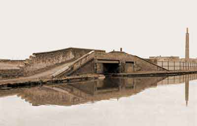
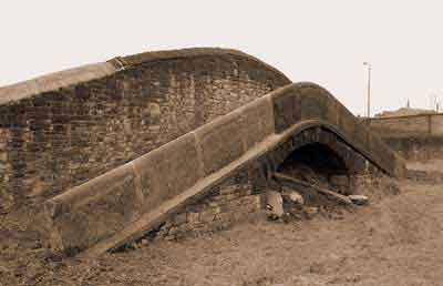
Clayton Junction between locks 10 and 11 of the Ashton Canal, Mar 1983. The side bridge carries the towpath of the Ashton Canal over the entrance to the Stockport Branch and it is listed Grade II, List Entry No. 1197794. The bricked-up entrance on the right accessed a canal basin belonging to the engineering firm of Armstrong Whitworth. |
Ashton Old Road (Pack Horse) Bridge, Openshaw, Mar 1980. View looking southwards and the towpath was on the right. |
 |
 |
Ogden Lane (Crab Croft) Bridge, Mar 1980. View looking southwards and the towpath was on the left. |
Side bridge over the canal arm into the Gorton Canal Depot and Boat Dock, Mar 1980. This bridge carried the towpath of the Stockport Branch over the arm leading into the canal depot. |
 |
 |
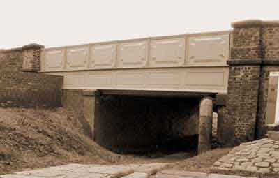
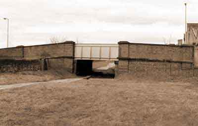
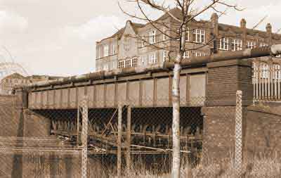
Gorton Aqueduct over the Manchester, Sheffield & Lincolnshire Railway/Great Central Railway main line, Mar 1980. This iron-trough aqueduct was constructed in 1905/06 to replace the original masonry aqueduct that was demolished when the railway line was widened. |
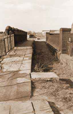
Gorton Aqueduct, Mar 1980. View looking northwards towards Clayton Junction. |
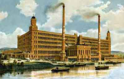 |
Broadstone Mills, Reddish. These cotton spinning mills were built on the eastern side of the Stockport Branch Canal adjoining Broadstone Rd. As built the complex was comprised of twin mills with central engine houses and a floor area of some 640,000 square feet. Construction work for the Broadstone Spinning Co Ltd commenced in 1903 and it was completed in 1907. It had 260,000 spindles. The mills were designed by Stott and Sons of Oldham. They are of red-brick construction on a steel frame with terracotta bands and a moulded dentil eaves cornice. Design features were octagonal turrets with copper cupolas at either end of the complex but only the northern one is still extant. The Broadstone Spinning Co Ltd was incorporated in 1904, Company No. 81586, and it went into voluntary liquidation in 1927. Later it was owned by Broadstone Mills Ltd. The complex closed as cotton spinning mills in 1959 after which it was converted for multi usage. The southern mill and engine houses were demolished in 1965. The surviving building now forms part of the Houldsworth Village development used for small businesses and as a shopping outlet. The surviving building, now known as Broadstone House, is listed Grade II, List Entry No. 1356825. |
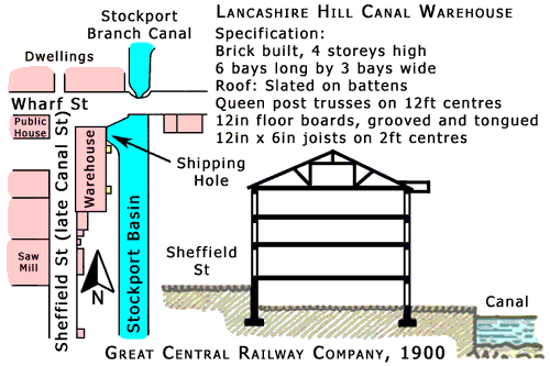
Stockport Canal Basin
This basin at the terminus of the Stockpoort Branch Canal was located just beyond Lancashire Hill Bridge in Stockport.
It was in a lozenge-shaped area of land bounded on the east by Lancashire Hill and Gordon St and on the west by Sheffield St and it was bisected by Wharf St.
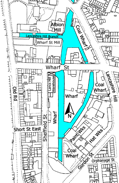
Stockport Canal Basin, 1896.
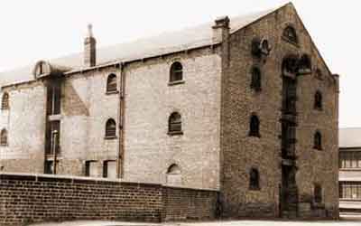
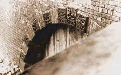
Albion Corn Mill, belonging to W Nelstrop & Company, and Lancashire Hill Canal Warehouse dominated the basin and the whole area was once a scene of considerable activity. Grain bound for this mill was one of the most important cargoes carried on the Stockport Branch. The keystone in the arched-shipping hole to the warehouse was engraved 'AC Co 1823' (Ashton Canal Company). It is understood that the warehouse was eventually used as a storehouse for grain and flour but it had to be demolished after a serious fire.
Besides Albion Corn Mill, the map of 1896 shows Wharf St Mill, a paint works and a hat works plus three coal wharfs and two other wharfs. However, the Canal Distance Table, produced by the Manchester, Sheffield and Lincolnshire Railway Company in Sep 1888, gives a clearer indication of the amount of industrial activity at Stockport Canal Basin. This has been reproduced below as accurately as possible and it includes the strikeouts and alterations. The distances are measured from Clayton Junction, which is where the Stockport Branch left the main line of the Ashton Canal between locks 10 and 11. These tables show that Stockport Canal Basin was only 18 chains (396 yards) long but in spite of this lots of industry was packed into this short distance.
| Distances from Clayton Junction | Miles | Chains |
|---|---|---|
| Lancashire Hill Bridge | 4 | 53 |
| 4 | 55 | |
| W. Nelstrop & Co's Albion Corn Mill | 4 | 55 |
| Company Wharf (CW): Junction of Lancashire Hill Branch for Hayes' Wharf | 4 | 56 |
| CW: D. Worth's Coal Wharf. Lee & Booth's Coal Wharf | 4 | 58 |
| Wharf Street Bridge | 4 | 59 |
| CW: Company's New Warehouse and Wharfs on both sides of canal | 4 | 61 |
| CW: Company's Sand Wharf, Company's Timber Wharf | 4 | 63 |
| CW: Company's Wharf | 4 | 65 |
| CW: H. Barlow & Son's Oil Works | 4 | 66 |
| CW: Coal Wharf. Company's Wharf occupied by L. Maiden & Co | 4 | 69 |
| CW: Coal Wharf | 4 | 71 |
The Stockport Branch was largely an urban canal that was heavily industrialised for most of its length. However, commercial carrying dwindled during the 1930s and eventually Stockport Canal Basin was closed. Nonetheless, traces of this were still visible in the late 1960s before it was finally filled in. Today, the only reminders of the existence the basin are Albion Corn Mill and Wharf St.
 |
 |
Lancashire Hill Canal Warehouse on the corner of Wharf St and Sheffield St (late Canal St), Stockport, 1961. Wharf St Bridge is in the foreground and Sheffield St is on the right. It is understood that this warehouse was eventually used by W Nelstrop & Company's Albion Corn Mill as a storehouse for grain and flour. It had to be demolished following a serious fire. One of the principal cargoes carried on the Stockport Branch Canal was grain destined for Albion Corn Mill. |
Detail of the arched-shipping hole accessing the Lancashire Hill Canal Warehouse, viewed from Wharf Street Bridge, 1967. Note the keystone incised with, 'AC Co 1823' (Ashton Canal Company). |